Levi Leiter Estate Minerals Available
State of Wyoming
Note: All lands subject to withdrawal without notice
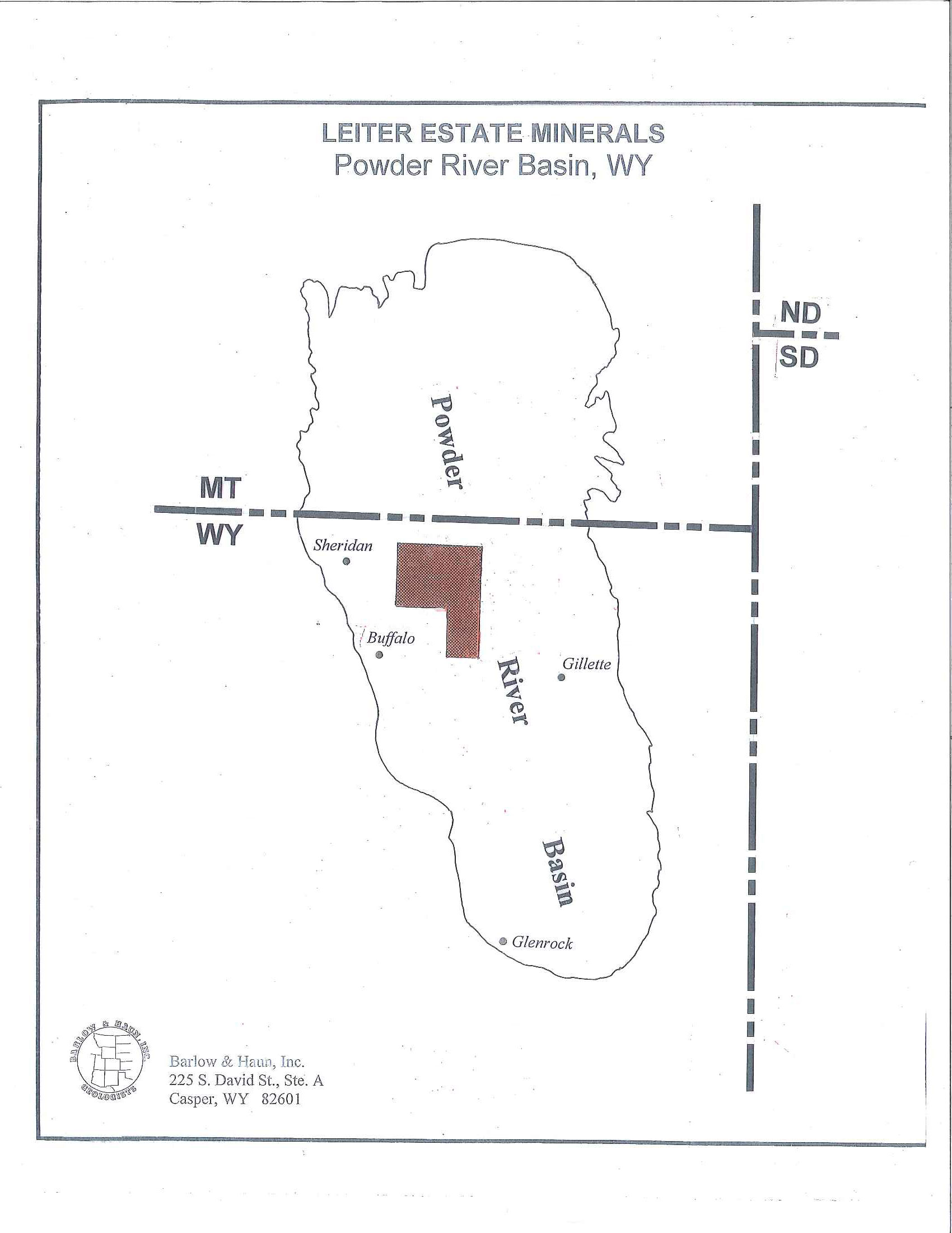
JOHNSON COUNTY, WYOMING
(1,159.21 acres)
T50N, R77W
Sections 8, 9, 16, 17: described as Tract 41 160.00
(fka Sec. 8: SE/4SE/4 and Sec. 17: N/2NE/4, SW/4NE/4)
(net acres 116.56)
T51N, R77W
Resurvey Tract 37 (formerly described as Lot 2, SW/4NE/4, SE/4NW/4 of Section 5) 119.21
Resurvey Tract 38 (formerly described as E/2SW/4 of Section 5 and the N/2NW/4 of Section 8) 160.00
Resurvey Tract 41 (formerly described as S/2NW/4, NW/4SE/4, SW/4NE/4 of Section 8) 160.00
Resurvey Tract 44 (formerly described as E/2NE/4 of Section 17) 80.00
Available lands are limited from the surface of the earth to the stratigraphic equivalent of the base of the Fort Union Coal Formation.
T52N, R77W
Section 3: S/2NW/4, N/2SW/4 (aka Tract 42), 160.00
S/2SW/4, W/2SE/4 (aka Tract 43) 160.00
T53N, R77W
Section 26: NE/4NW/4, W/2NE/4, SE/4NE/4
(aka Tracts 83A, 83B, 83C, 83D) 160.00
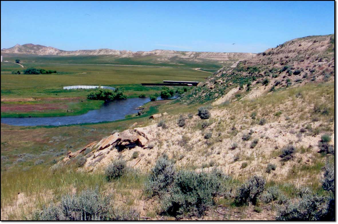
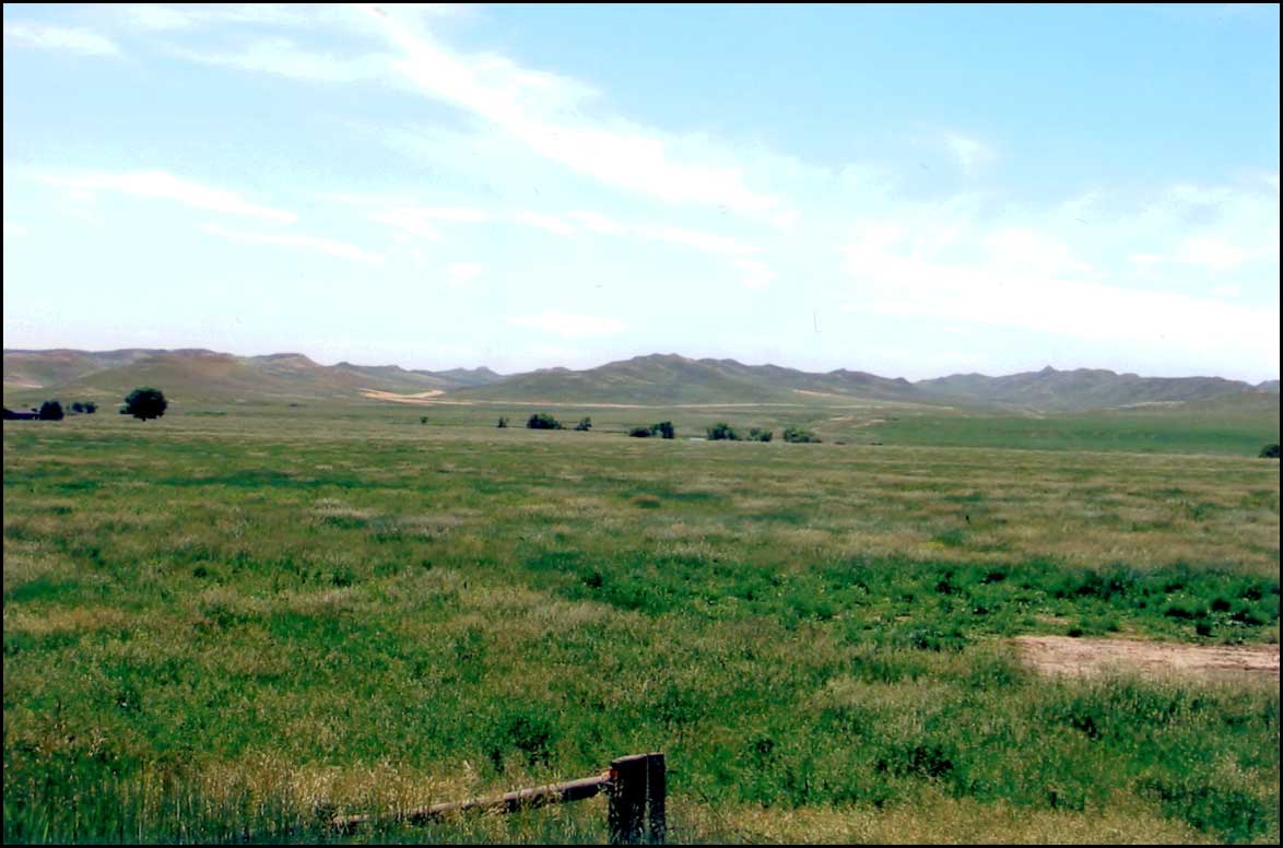
SHERIDAN COUNTY, WYOMING
(16,082.20 acres)
T53N, R79W
Section 6: N/2NE/4 (Tract 47) 79.43
Lots 6, 7, 9, 10, 11 (Tract 49) 158.42
Lots 12, 13, 14 (Tract 52) 103.75
Section 7: Lots 2 & 3 (Tract 52) 158.03
Lots 1, 4, 5, 6, 9 (Tract 53) 158.52
T53N, R80W
Section 1: SE/4SE/4 40.00
Section 7: SE/4SE/4 40.00
Section 8: S/2SW/4, SE/4 240.00
Section 9: S/2 320.00
Section 10: S/2, S/2N/2 480.00
Section 11: N/2, N/2S/2 480.00
Section 12: N/2, N/2S/2 480.00
Section 16: All 640.00
Section 17: All 640.00
Section 18: NE/4NE/4 40.00
T54N, R76W
Section 18: Lots 3 & 4, SE/4SW/4 111.21
Section 20: SE/4SE/4 40.00
T54N, R77W
Section 35: E/2SE/4 80.00
T54N, R79W
Section 2: Lot 4, SW/4NW/4 80.89
Section 3: Lots 1 & 2, SE/4NW/4, E/2SW/4, SE/4, S/2NE/4 440.72
Section 9: SW/4SE/4, E/2SE/4, SE/4NE/4 160.00
Section 10: W/2SW/4, NW/4, W/2NE/4, NE/4NE/4 360.00
Section 16: E/2NW/4, E/2 400.00
Section 21: S/2SW/4, NE/4SW/4, N/2SE/4, W/2NE/4 280.00
Portion of N/2SW/4 described as follows:
All that portion of the North half of the Southwest quarter (N/2SW/4) of Section 21, lying between a line 50 feet South and parallel with the centerline of the South track of the Wyoming Railroad and a line 45 feet South and East and parallel with the centerline of the Pratt and Ferris No. 2 ditch, as the same is located and constructed over and across said North half of the Southwest quarter (N/2SW/4) of Section
21. 15.00
Section 29: Portion of E/2SW/4 described as follows:
A strip of land 125 feet in width, lying 75 feet on the Northwesterly side and 50 feet on the Southeasterly sided of the following described centerline:
Commencing at a point in the center of the Pratt and Ferris No. 2 ditch headgate, said point being North 83º 07' West, 3,604 feet from the Southeast corner of Section 29; thence North 58º 00' East, 230 feet to a point in the centerline of the Pratt and Ferris No. 2 ditch, said point being North 80º 30' West, 3,432 feet from the Southeast corner of Section 29.
Also a strip of land 100 feet in width lying 50 feet on each side of the following described centerline: Commencing at a point that is North 80º 30' West, 3,432 feet from the Southeast corner of Section 29; thence North 31º 00' East, 220 feet; thence North 27º 15' East, 810 feet; thence North 14º 20' East 100 feet; thence North 3º 45' East, 100 feet; thence North 80º 15' West, 450 feet to a point in the center of the Pratt and Ferris No. 2 ditch, said point being North 54º 10' West, 3,615 feet from the Southeast corner of Section 29.
Also a strip of land 80 feet in width, lying 40 feet on the West side and 20 feet on the East side of the following described centerline of the Pratt and Ferris No. 2 ditch:
Commencing at a point in the center of the Pratt and Ferris No. 2 ditch, said point being North 54º 10' West, 3,615 feet from the Southeast corner of Section 29; thence North 11º 50' West, 37 feet, more or less; thence North 7º 15' West, 100 feet; thence North 7º 35' East, 100 feet; thence North 14º 10' East, 210 feet, more or less, to the South right-of-way line of the State Highway, the East and West lines of this tract being produced in each case to intersect the South right-of-way line of the State Highway, said Highway bears South 44º 20' West. The total area in the above bract being 4.5 acres, of which 1.1 acres are included within the old right-of-way area, excepting therefrom and subject to the reservations to the Grantors of that certain Deed by S. P. Morgan and Nettie Morgan, his wife, to the Trustees under the Last Will and Testament of Levi Z. Leiter, deceased, dated October 18, 1924, and recorded in the office of the County Clerk of Sheridan County, Wyoming, in Book 21 of Deeds, Page 467, a right-of-way over and across said tract of land for a certain ditch of the said grantors, known as the Morgan Ditch, now crossing the same, and the right to use, operate and maintain said ditch for the propose of irrigating the lands of the said Grantors; also a right-of-way for a wagon road across said tract of land at such point as may be selected by the Grantors. 6.00 Section 30: Lot 2, NE/4SW/4, NW/4SE/4 119.91
Section 31: S/2SE/4 80.00
T54N, R80W
Section 1: Lot 3 & SE/4NE/4 80.04
Section 2: SE/4SE/4 40.00
Section 3: Lot 1 40.26
Section 5: Lot 3, SE/4NW/4, SE/4 240.21
Section 6: Lot 7 39.63
Section 7: Lot 1 & NE/4SE/4 79.71
Section 9: SE/4SE/4, N/2SE/4, SW/4NE/4 160.00
Section 10: SW/4SW/4 40.00
Section 11: NE/4NE/4 40.00
Section 14: NW/4SW/4, SE/4SW/4, SW/4SE/4 120.00
Section 15: N/2NW/4 80.00
Section 18: Lot 4 & SE/4SW/4 80.50
Section 19: N/2NE/4 80.00
Section 20: NW/4NW/4, SE/4NW/4, N/2NE/4 160.00
Section 21: N/2N/2 160.00
Section 22: S/2NW/4, NE/4SE/4, SW/4NE/4 160.00
Section 23: W/2SW/4, NE/4SW/4, S/2SE/4 200.00
Section 25: N/2NW/4, SW/4NE/4, E/2NE/4 200.00
Section 26: NW/4NW/4 40.00
Available lands are limited from the surface of the earth to 3,000 feet.
T54N, R81W
Section 13: E/2NW/4, N/2SW/4, SW/4SW/4, SE/4SE/4, NW/4SE/4, SW/4NE/4 320.00
Section 14: SW/4SW/4, E/2SE/4 120.00
Section 23: NW/4NW/4, NE/4NE/4 80.00
Available lands are limited from the surface of the earth to 3,000 feet.
T55N, R77W
Section 19: Lot 4 (Tract 57) 28.60
Section 34: N/2NW/4, SE/4NW/4, NE/4SW/4 (Tract 66) 160.00
T55N, R78W
Section 10: SW/4SE/4 (Tract 50) 40.00
SE/4SE/4
Section 11: S/2SW/4
Section 15: N/2SE/4, NE/4 (Tract 51) 360.00
EXCEPTING from Tract 51, all that part originally described as the S/2SW/4 Section 11 and all that part of the SE/4SE/4 of Section 10 lying South and East of a line beginning at a point in the Northerly line of said SE/4SE/4 Section 10, 128 feet West of the Northeast corner of said SE/4SE/4 Section 10: thence South 21º 50' East, 40 feet; thence South 15º 00' West, 460 feet; thence South 25º 25' West, 710 feet; thence South 45º 50' West, 256 feet to a point on the Southerly line of the SE/4 Section 10, 720 feet Westerly of the Southeasterly corner of the SE/4 of Section 10, said excepted tract containing 90.00 acres, more or less.
S/2NW/4, SW/4
Section 16: SE/4NW/4, SW/4SW/4, E/2SW/4, SE/4, S/2NE/4, NE/4NE/4 (Part of Tract 66) 440.00
Section 19: S/2NE/4 (Tract 74) 80.00
Lots 3 & 4 (Tract 75) 116.02
E/2SW/4, SE/4
Section 20: SW/4SW/4
S/2N/2, N/2S/2, SE/4SW/4, SW/4SE/4, SE/4SE/4
NE/4NE/4 (Tract 79) 40.00
Section 21: N/2, N/2S/2 (Tract 80) 476.96
EXCEPTING from Tract 80, according to original survey, a tract of land 100 feet wide on the southerly side of and adjoining the southerly line of the right-of-way of the railroad (as of 10-27-16), said excepted tract containing 3.04 acres +/-, extending over and across the NW/4SW/4 of Section 21. Section 22: N/2NW/4 (Tract 65) 320.00
Section 24: SW/4SE/4 (Tract 88) 33.84
EXCEPTING from Tract 88, according to original survey, a tract of land in the SW/4SE/4 Section 24 as follows: Beginning at a point on the north/south centerline of Section 24, 100 feet north of the centerline of the main track of the Chicago Burlington and Quincy Railroad Company, as the same was located as of 11-1-20; thence north 300 feet; thence easterly, parallel with said centerline of the railroad 810 feet; thence south, parallel with said north/south centerline, 200 feet; thence easterly, parallel with said centerline of the railroad to the east line of the SW/4SE/4 of said Section 24; thence south in said east line 100 feet; thence west, parallel with said center line of the railroad along the northerly right-of-way line to the point of beginning, said excepted tract containing 6.16 acres, more or less. Section 29: NW/4NW/4 NE/4NW/4 (Tract 77) 479.83
EXCEPTING from Tract 77 according to original survey, a tract of land in the SE/4SE/4 Section 20 as follows: Beginning at a point which is North 52º 20' West, 809.6 feet from the common Section corner of Sections 20, 21, 28, and 29: thence North 150 feet; thence West 50 feet; thence South 150 feet; thence East 50 feet to the point of beginning, said excepted tract containing 0.172 acres, more or less.
NW/4NE/4 (Tract 97) 40.00 SW/4NW/4 (Tract 98) 40.00
Section 30: Lots 1&2, N/2NE/4, SW/4NE/4, E/2NW/4 (Tract 76) 636.92
N/2SE/4 (Tract 91) 80.00
Lots 3 & 4, E/2SW/4 (Tract 92) 197.80
SE/4NE/4 (Tract 100) 40.00
T55N, R79W
Section 24: SE/4NW/4, SW/4SW/4, E/2SW/4, SE/4, S/2NE/4 400.00
Section 25: All 640.00
Section 26: E/2E/2 160.00
Section 34: SE/4, SE/4NE/4 200.00
Section 35: NE/4NW/4, S/2NW/4, S/2, NE/4 600.00
Section 36: All 640.00
T55N, R80W
Section 14: W/2NE/4 80.00
Section 15: SE/4NW/4, SW/4NE/4 80.00
Section 33: SE/4NW/4, SW/4NE/4 80.00
Section 34: SW/4NW/4, N/2SW/4, SE/4SW/4, SW/4SE/4 200.00
Section 35: W/2NW/4, SE/4NW/4, SE/4SE/4 160.00
Available lands are limited from the surface of the earth to 3,000 feet.
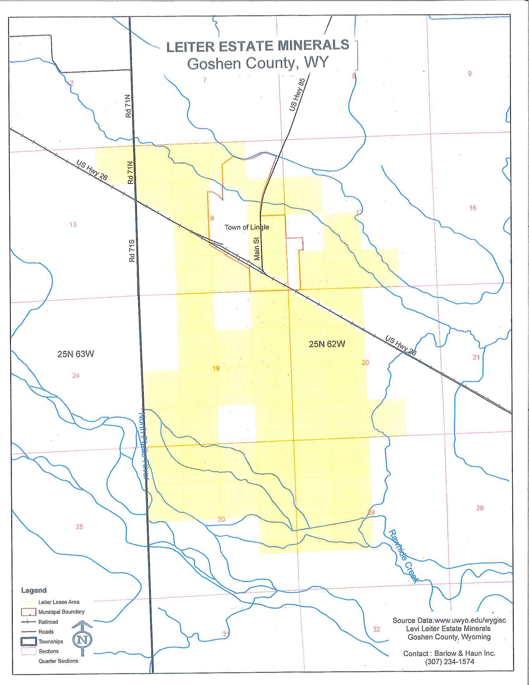
T25N, R62W
Section 17:
SW/4NW/4, SW/4SE/4. E/2SW/4, SW/4SW/4, less and except the following:
Block 1:
All Block 2:
All Block 3: Lot 1, Lot 2, Lot 3, Lot 4, Lot 5, Lot 6, Lot 7, Lot 8, Lot 11, Lot 12, Lot 13, Lot 14, Lot 15, and Lot 16
Block 4: All
all in Leiter’s First Subdivision, Town of Lingle as platted on Plat #63 of the records of the County Clerk of Goshen County, Wyoming.
Section 18:
That part of Lot 1 (37.78) and Lot 2 (37.80) lying north of the C. B. & Q. Railroad Right of Way, E/2W/2, SE/4NE/4, that part of the W/2NE/4 lying north of the Lucerne Canal, that part of the W/2SE/4 lying south of the C. B. & Q. Railroad Right of Way, E/2SE/4, less and except the following:
The C. B. & Q. Railroad Right of Way
Block 1: Lot 1, Lot 2, Lot 6, and Lot 7
Block 2: All
Block 3: All
Block 4: All
Block 5: All
Block 6: All
Block 7: All
Block 8: All
Block 9: All
Block 10: All
Block 11: All
Block 12: Lot 1, Lot 2, Lot 3, Lot 4, Lot 5, Lot 6, Lot 7, Lot 9, Lot 10, Lot 11, and Lot 12
And further excepting:
Beginning at a point in the prolongation of the west side of Main Street in the Original Town of Lingle, Wyoming, which point is 80 feet north of the northeast corner of Lot 1 of Block 3 of said Original Town as plotted and recorded in the records of the County Clerk of Goshen County, Wyoming, thence west parallel to and 80 feet from the north boundary of said Original Town a distance of 380 feet to a point, thence north along the east boundary of Walker’s Addition to the Town of Lingle a distance of 250 feet to a point; thence east parallel to and 330 feet from said north boundary of said Original Town of Lingle a distance of 480 feet to a point; thence south along said prolongation to the west side of Main Street a distance of 250 feet more or less to the point of beginning. Said tract contains 2.75 acres more or less and first described at Book 121 Page 68 of the Goshen County records.
All in the Original Town of Lingle as platted on Plat #65 of the records of the County Clerk of Goshen County, Wyoming.
Section 19: Lot 3 (38.19), Lot 4 (38.32), E/2SW/4, NW/4SE/4, E/2SE/4, SW/4NE/4, E/2NW/4, E/2NE/4, less and except the C. B. & Q. Railroad Right of Way
Section 20: SW/4, SW/4SE/4, NW/4 less and except:
All of Block 4, Leiter’s First Subdivision, Town of Lingle, the C. B. & Q. Railroad Right of Way
Section 29: NW/4, N/2SW/4
Section 30: Lot 1 (38.50), Lot 2 (38.70), E/2NW/4, NE/4, NE/4SE/4
T25N, R63W
Section 13: That part of the NE/4NE/4 lying north of the C. B. & Q. Railroad Right of Way
Barlow & Haun, Inc.
225 So. David Street, Ste. A
Casper, WY 82601
(307)-234-1574
bhgeolwy@bresnan.net